Although rather better-known for its North Sea exploration, Britain has more than 2000 onshore oil and gas wells. If shale gas exploration takes off, this number will increase significantly and one of the big questions is what percentage of these wells might leak, and over what time scale.
The existing hydrocarbon wells give us a chance to investigate this and also the regulatory system in place. Where are the wells and who monitors them?
To begin finding out, a couple of Durham colleagues and I went out for an oil well reconnaissance around north-east England. It was a splendid summer morning and oil seemed well with the world. Sorry.
I came up by train, and almost immediately upon departing the railway station car park, we encountered some hitch-hikers in fancy dress, so we picked them up. They were trying to get as far south as possible in 36 hours and though we could only take them to the slip road of the A1, it was a start.
For us, a start was to be found in a field at Shalter's Bridge, just south of Aycliffe. There was supposed to be a well there, drilled by Enterprise Oil in 1989, so we parked on the road outside some open electric gates and walked up the driveway. At the end, two chaps were working on a building site. As we approached, one of them saw us and walked towards us. His greeting was slightly surprising.
"Are you here for a fight?"
No, we assured him, we definitely weren't. We just wondered if there was an oil well in his field.
He seemed to think there had been, but he wasn't sure quite where. What he was more certain about was that we'd find Charlie McCrory in the field and that he was a bit daft. We were welcome to go into the field and have a look though.
Charlie McCrory turned out to be a horse, and when we climbed over the fence he didn't seem too maddened by our presence.
"We could do with a metal detector," said one of my colleagues.
"Probably," I replied, "though we might be able to make do with a nettle detector..."
I was standing in the only patch of nettles in the field, and knowing that stinging nettles often indicate disturbance and elevated nutrient levels, I speculated that it might be our spot. It was certainly close to where the map indicated the well should be, and though we couldn't see anything conclusive, we decided it was our best candidate.
We left Charlie McCrory to his own devices and returned to the car.
Locality 2 was in a field next to Claxton House Farm, between Billingham and Hartlepool. A well had been drilled here by British Petroleum in 1960-61, and the map indicated it was close to a public footpath, so we parked up again and had a wander along the path.
It was a perfectly pleasant field, but unremarkable. At the corner where the map said the well was, there was absolutely no sign of any major drilling operations. It had been over half-a-century, we supposed, but we'd thought there might be some hint of its presence. Ah well, on to the next one.
The next one was a housing development on the site of the old Newell glass factory at Millfield, Sunderland. Alkane had drilled a gas well there in April 2002.
There were lots of workmen busy in building houses, but no-one we could actually ask. We wandered around the site for a while with our map, trying to figure out where the well would have been. Eventually a man called Dave came our way and seemed to know what we were talking about.
Someone else had visited a while back, Dave said, asking about the same thing. He took us to the back of the Portakabin serving as the site office, lifted up some pallets, and there it was. A real, (not very) old gas well. Not especially exciting, but good to finally find one.
Having found it, we wondered what would happen to it next. We didn't grill Dave, but presumably it will get filled in before too long and then buried beneath the new housing estate.
Our fourth and final location was rather a change of scene: St Mary's Island nature reserve on the coast near Whitley Bay.
An exploration oil well had apparently been drilled somewhere just inland of the reserve in 1967, perhaps appropriately by a company called Safari, but we couldn't find it. We did confuse a birdwatcher when we mentioned what we were looking for: he'd been coming here for years, he said, and didn't know anything about it.
After a few more minutes of patrolling the perimeter of the reserve we realized it was definitely needle-haystack territory. Without serious exploration kit we were never going to find anything. We headed back to the car.
It did plant an idea though. Since a map of all onshore oil and gas wells is available through the British Geological Survey GeoIndex Onshore, we wondered about starting a new Citizen Science project.
People around the country could look up their local areas, choose 'Onshore hydrocarbon wells' in the Map Layers option, and find out if any wells are in their vicinity. They could then go and have a look for the wells and see what condition they are in, and whether anyone is monitoring them.
It should probably be called something simple and sensible like UK Well Search, but I'm always keen on puns. "Oil's Well That Ends Well" might work, or "Where's Welly?" Or indeed, "Good Well Hunting".
If you've got any better suggestions, I'll be happy to hear them. And if you find any wells yourself, I'll be happy to hear about that too.
The existing hydrocarbon wells give us a chance to investigate this and also the regulatory system in place. Where are the wells and who monitors them?
 |
| The oldest onshore oil well in England. It is owned by this chap. |
To begin finding out, a couple of Durham colleagues and I went out for an oil well reconnaissance around north-east England. It was a splendid summer morning and oil seemed well with the world. Sorry.
I came up by train, and almost immediately upon departing the railway station car park, we encountered some hitch-hikers in fancy dress, so we picked them up. They were trying to get as far south as possible in 36 hours and though we could only take them to the slip road of the A1, it was a start.
For us, a start was to be found in a field at Shalter's Bridge, just south of Aycliffe. There was supposed to be a well there, drilled by Enterprise Oil in 1989, so we parked on the road outside some open electric gates and walked up the driveway. At the end, two chaps were working on a building site. As we approached, one of them saw us and walked towards us. His greeting was slightly surprising.
"Are you here for a fight?"
No, we assured him, we definitely weren't. We just wondered if there was an oil well in his field.
He seemed to think there had been, but he wasn't sure quite where. What he was more certain about was that we'd find Charlie McCrory in the field and that he was a bit daft. We were welcome to go into the field and have a look though.
Charlie McCrory turned out to be a horse, and when we climbed over the fence he didn't seem too maddened by our presence.
"We could do with a metal detector," said one of my colleagues.
"Probably," I replied, "though we might be able to make do with a nettle detector..."
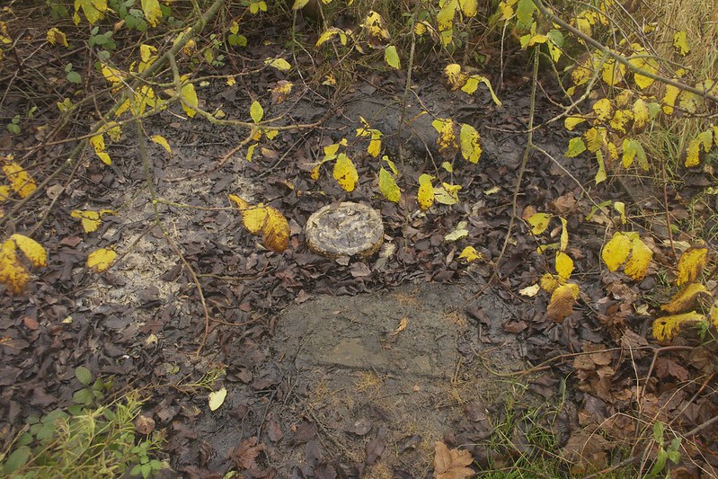
 |
| Shalter's Bridge |
I was standing in the only patch of nettles in the field, and knowing that stinging nettles often indicate disturbance and elevated nutrient levels, I speculated that it might be our spot. It was certainly close to where the map indicated the well should be, and though we couldn't see anything conclusive, we decided it was our best candidate.
We left Charlie McCrory to his own devices and returned to the car.
Locality 2 was in a field next to Claxton House Farm, between Billingham and Hartlepool. A well had been drilled here by British Petroleum in 1960-61, and the map indicated it was close to a public footpath, so we parked up again and had a wander along the path.
It was a perfectly pleasant field, but unremarkable. At the corner where the map said the well was, there was absolutely no sign of any major drilling operations. It had been over half-a-century, we supposed, but we'd thought there might be some hint of its presence. Ah well, on to the next one.
 |
| Claxton House Farm |
The next one was a housing development on the site of the old Newell glass factory at Millfield, Sunderland. Alkane had drilled a gas well there in April 2002.
There were lots of workmen busy in building houses, but no-one we could actually ask. We wandered around the site for a while with our map, trying to figure out where the well would have been. Eventually a man called Dave came our way and seemed to know what we were talking about.
Someone else had visited a while back, Dave said, asking about the same thing. He took us to the back of the Portakabin serving as the site office, lifted up some pallets, and there it was. A real, (not very) old gas well. Not especially exciting, but good to finally find one.
 |
| Newell Glassworks |
Having found it, we wondered what would happen to it next. We didn't grill Dave, but presumably it will get filled in before too long and then buried beneath the new housing estate.
Our fourth and final location was rather a change of scene: St Mary's Island nature reserve on the coast near Whitley Bay.
 |
| St Mary's Island |
An exploration oil well had apparently been drilled somewhere just inland of the reserve in 1967, perhaps appropriately by a company called Safari, but we couldn't find it. We did confuse a birdwatcher when we mentioned what we were looking for: he'd been coming here for years, he said, and didn't know anything about it.
After a few more minutes of patrolling the perimeter of the reserve we realized it was definitely needle-haystack territory. Without serious exploration kit we were never going to find anything. We headed back to the car.
It did plant an idea though. Since a map of all onshore oil and gas wells is available through the British Geological Survey GeoIndex Onshore, we wondered about starting a new Citizen Science project.
People around the country could look up their local areas, choose 'Onshore hydrocarbon wells' in the Map Layers option, and find out if any wells are in their vicinity. They could then go and have a look for the wells and see what condition they are in, and whether anyone is monitoring them.
It should probably be called something simple and sensible like UK Well Search, but I'm always keen on puns. "Oil's Well That Ends Well" might work, or "Where's Welly?" Or indeed, "Good Well Hunting".
If you've got any better suggestions, I'll be happy to hear them. And if you find any wells yourself, I'll be happy to hear about that too.
Comments